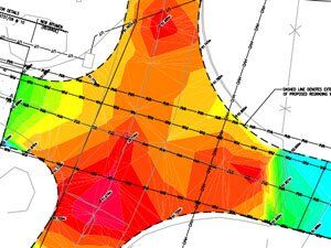
This work requires the modelling of earthworks taking into account the regrading of sites to achieve development plateaus that recognise drainage levels, subsurface structures and any contamination.
Geological information is incorporated into an earthworks model by use of Holebase which generates contoured surfaces that can be imported into AutoCAD 3D. This seamless interface of geological strata elevations is unique as it allows for sophisticated cut/fill modelling generating quantities of different soil materials.
The model allows for calculating an optimal cut/fill balance which minimises haul distances and material removed offsite.
Using the model we can estimate the quantity of surface/subsurface hard material that can be crushed to form 6F2/6F5 material that may be required for use as road/pavement areas capping, piling platforms or as structural fill.
The distribution of contamination in soil or groundwater can be represented in a three dimensional form with the earthworks model used to assess soil inversion to eliminate pollutant linkages, removing the need to export material to landfill sites.


